Clarity Consulting

The dataset

A point cloud is a 3D snapshot made of measurements

Picture millions of tiny dots, each one marking an exact point in space where a laser pulse struck a real surface. Together they form a detailed virtual replica of a building, a landscape or an object — accurate enough to measure against.

That replica can be measured remotely, checked for change between visits, and used to plan renovation or construction without anyone returning to site. Every point also carries extra information: how strongly it reflected (intensity), and often its true colour.

The practical consequence: a question you had not thought of during the survey is still answerable afterwards, because the data was captured whether or not anyone asked for it.

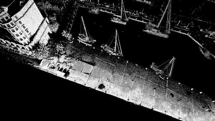
Intensity-shaded LiDAR point cloud of a quay viewed from above, with individual points clearly resolvable on the deck surface
Intensity returns. Brightness encodes how reflective each surface is, which makes material and condition readable.

The process

Six steps from pulse to product

  1. 01

    Emit

    Many laser beams fire at once, not one. The whole sensor head also rotates on a second axis, so the beams sweep a near-spherical volume around it rather than tracing a single flat plane.

  2. 02

    Return

    Each pulse reflects from the first surface it meets. Some pass through gaps in foliage and return from deeper, which is why a single scan can see both canopy and ground.

  3. 03

    Time

    The time between emission and return gives distance, to within millimetres. Return strength is recorded too — that is the intensity value.

  4. 04

    Position

    The sensor works out where it is from the scan data itself, matching each sweep against the ones before it — a technique called SLAM. No satellite fix is required, which is what makes indoors, underground and dense canopy practical rather than impossible.

  5. 05

    Register

    Individual passes are aligned into one consistent cloud and, where absolute position matters, tied to surveyed ground control — so the result is georeferenced to the national grid rather than merely self-consistent.

  6. 06

    Classify

    Points are sorted into ground, vegetation, buildings and noise. This is where a raw cloud becomes a dataset you can extract surfaces and volumes from.

The instrument

Not all LiDAR is the same shape

Most people picture a single laser tracing one line, and a great deal of survey LiDAR still works exactly that way. The distinction matters more than it sounds, because it decides what a survey can and cannot reach.

A single-channel profiler

  • One beam sweeping one flat plane
  • Becomes 3D only because the vehicle carrying it moves forward
  • Accuracy is only as good as the satellite and inertial positioning behind it
  • Whatever the plane does not sweep is simply not captured

What we operate

  • Many beams firing simultaneously, not one
  • The sensor head rotates on a second axis, so coverage is near-spherical from every position
  • Position derived from the scan data itself, so no satellite fix is needed
  • Under ledges, up walls, behind obstructions — captured in the same pass

Why this matters to you rather than to us. Coverage is complete in a single pass, so there are fewer setups and less time on your site. Places satellite positioning cannot reach — inside buildings, covered sheds, tunnels, beneath closed canopy, between tall structures — are ordinary jobs rather than special cases. And because the same sensor can be carried, driven or flown, a site with an indoor half and an outdoor half is one survey producing one dataset, not two surveys stitched together afterwards and hoped for the best.

Capture platforms

Choosing the right one is most of the job

Each platform has a shape of site it suits and a shape it does not. Being straight about the limits is how you avoid paying for a survey that comes back with holes in it.

Walk-through (SLAM)

Best for: Interiors, covered sheds, quaysides, dense sites

A scanner carried at walking pace, building its own position from the scan data rather than from satellites. This is what makes indoor and covered capture possible, and it works around live operations without closing a site.

Range is shorter than airborne capture, so very large open sites take longer.

Vehicle-mounted

Best for: Roads, corridors, estates, port yards

The same principle at driving speed. Kilometres of corridor captured in a single pass, with the sensor high enough to see over kerbs, barriers and parked vehicles.

Only captures what is visible from the carriageway — it cannot see behind a solid boundary wall.

UAV LiDAR

Best for: Open terrain, roofs, vegetation, large areas

Elevated capture covering ground that would take days to walk. The nadir and oblique angles reach roofs, embankments and canopy that no ground-based platform can see.

Weather and airspace dependent, and needs sky visibility — so not an option under cover.

UAV photogrammetry (Zenmuse P1)

Best for: Orthomosaics, textured models, visual condition

A 45 MP full-frame sensor with a mechanical global shutter, flown RTK. The global shutter is what keeps geometry true while the aircraft is moving — the difference between survey-grade and consumer aerial imagery.

Infers geometry rather than measuring it. Struggles under vegetation, on featureless or reflective surfaces, and in flat light.

A fair comparison

LiDAR or photogrammetry?

We operate both, so we have no reason to talk one of them up. LiDAR measures distance directly with laser pulses. Photogrammetry infers geometry by matching features across overlapping photographs — in our case from a 45 MP full-frame Zenmuse P1.

LiDAR is stronger when

  • Vegetation stands between the sensor and the ground
  • Surfaces are featureless — plain walls, water, fresh concrete
  • Lighting is poor, or the space has no natural light at all
  • Absolute dimensional accuracy is the point of the exercise

Photogrammetry is stronger when

  • Visual texture and colour fidelity matter most
  • The subject is small, well lit and richly detailed
  • Budget is the binding constraint and tolerances are loose
  • The deliverable is a visualisation rather than a measurement

In practice we increasingly fly both on the same sortie and fuse the results — laser returns for the geometry you will measure against, P1 imagery for the colour, texture and orthomosaic you will actually show people. See aerial photogrammetry for what that produces.

Still deciding whether this fits your project?

Describe the site and the question. We will tell you which platform we would use, what it would capture, and where its limits would be.